Onderzoeksmethoden 2/het werk/2010-11/Groep04
Inhoud
Introduction
Climate change and global warming are hot topics. The Dutch government (and European Union) wants to become less dependent on oil-producting countries, and also wants to focus on alternative sources of energy, so called: green energy. Windturbines are seen as an important source for green energy for our climate. They deliver many megawatts of energy and are becoming more efficient every day.
However, many people think windturbines look ugly, take away too much space and ruin nature.
It is, however, not a question if windturbines are being placed in the upcoming years, but where they should be placed. So the question that arises is:
“What is the best location in The Netherlands to place windturbines according to RU students?”
This research tries to find an answer to this question. In a collaborative group session we want group members to think creatively and decide where to place windturbines in-land.
Students are given a map on which they can pinpoint possible locations for windturbines. Everyone needs to agree with the proposed location.
To make things interesting, everyone has 1 veto right to prevent a location from being used.
Chosen research method: Workshops
Our group consists of the following members:
Problem statement
Climate change and global warming are hot topics.
Some scientists believe the earth may become uninhabitable in a few hundred years due to global warming primarily caused by CO2 pollution [1]. Another point of interest is that we may run out of oil in the next few decades. Whether this is true or not, a fact is that a lot of the oil-producing countries (OPEC) are instable and one of the most important products for a country ‘energy’ cannot always be guaranteed.
The Dutch government (and European Union) not only wants to become less dependent on these oil-producting countries, but also wants to focus on alternative sources of energy, so called: green energy. This type of energy could be produced by all countries in the european union and would produce less to zero CO2.
A win-win situation you might say. Save the earth on one side and be independent of other countries on the other side.
The Dutch government currently sees wind turbines as an important source for green energy for our climate. They deliver many megawatts of energy and are becoming more efficient every day.
Many people think wind turbines look ugly, take away too much space and ruin nature. So it’s probably best for ‘cosmetic’ reasons not to place too many windturbines in-land. However, in-land windturbines are cheaper and offer a better return on investment over windturbines that are stationed on sea [2].
The problem is that people don't just accept a large (and tall) wind turbine (100m) in their ‘backyard’.[3] But they have be placed somewhere. So the question that arises is:
“What is the best location in The Netherlands
to place windturbines according to RU students?”
Other topics that may be of interest for this research are:
- How can we make wind turbines more appealing?
- Do windturbines really ruin nature
Expected outcome:
Students probably choose a location for the windturbines at the edge of a city or in pastures.
Students won’t unanimously agree on every location because of personal interest (NIMBY).
We do however believe that at the end of the workshop everyone can live with the decisions made and will accept the outcome. This would eventually happen in real-life too if the test subjects are chosen in such a way that it matches the population. People will accept the windtubines as our new form of energy.
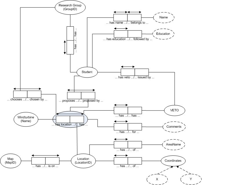
Conceptual model
Method
There are many answers to the question where to put the windturbines, though none is in all cases the best answer. It depends on the people involved what the best answer is. The workshop-method is best suitable to approach such a problem.
So, why did we choose The Netherlands? There are a number of reasons for this.
First and foremost, The Netherlands is a country in which windturbines are actively supported by politics and are actively discussed in the media.
Secondly, most people in The Netherlands have seen windturbines in real-life and have some sort of representation of them.
Research cases
Students
We choose Radboud students because they are highly educated and they are young. It is shown that highly educated young people are the most aware of environmental problems and are most willing to act. So we choose students between 20-30 years old.
Why did we choose students between 20-30 years old? Students need to be of a certain age to be able to really think about environmental problems.
If someone is too young they don't have the required experience in life yet. On the other hand, if someone is too old we can't really call them a student anymore.
Variables
Independent variables
Preference of student (student)
The preference of workshop participants is key to where the windturbines will be placed. This is the independent variable.
Dependent
Windturbine location (dependent on preference of student)
The participants choose the location of the windturbines on the map, this is the dependent variable.
Map
A typical Dutch town has several types of land-use. The map we constructed has the following areas:
- Residential area
- Industry
- Farmland/Pastures
- Commercial area/Industry
- Water
- Parks
We have chosen these areas because they are common in a typical Dutch town. The map we constructed is based on Arnhem.
We decided to keep the original street names because we are using Google Streetview. (This will be explained in more detail later)
Because the names are in Dutch and our participants speak Dutch, it is easier for them to communicate and lookup streets.
Windturbine
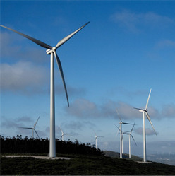
The larger the turbine, the greater the challange to find a good spot to place them. So we use a huge windturbine
Make / Type: Vestas V90-3.0 MW [4].
Height: up to 105 m.
Rotor diameter: 90 m.
Swept area: 6362 m2
Approach
In this paragraph we explain the approach we are going to use to present the workshop to the participants. We also explain how we address internal and external validity of the research.
Research cases
Students
For this research we need 8 students, which will be divided into two groups of 4. In each group there will be 2 men (1 alpha, 1 beta) and 2 women (1 alpha, 1 beta). The age of all students in the group must have an average of 24-26. Students will be randomly selected in the lunch room of the different faculties of the Radboud University Nijmegen.
Windturbine
In this research we use 5 windturbines that are at least 100 meters high.
Plan of Approach
Map
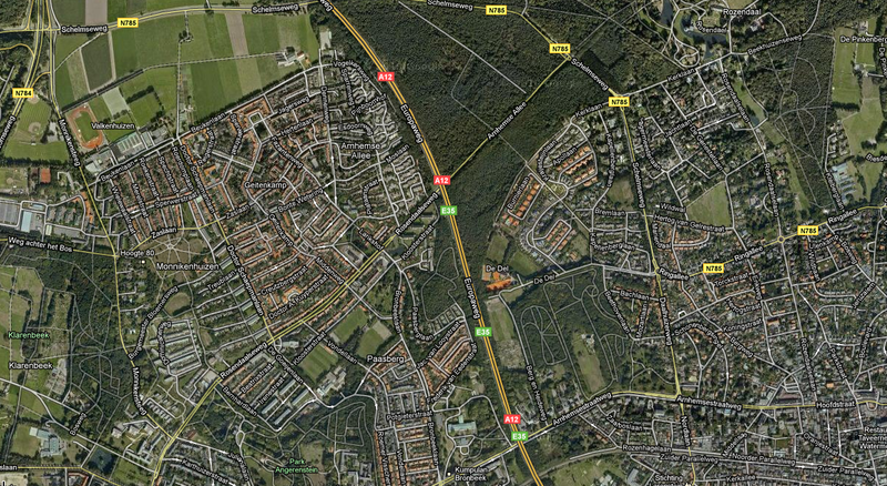
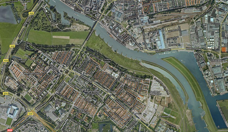
Each group is provided with a paper (A3 format) satellite map of a real city, located in The Netherlands. All streets are labeled with their real names. It is important that each type of area is present on the map. We distinguish the following area types:
- Industry (~20%)
- Harbour/Water (~10%)
- Forrest (~ 5%)
- Pastures (~10%)
- Residential/parks (~50%-60%)
We have choosen to divide the map in areas in order to be able to draw a conclusion.
Locations on the map need to be distinguished since we cannot have a specific street as outcome. We need to be able to generalize and not be dependent on a specific city.
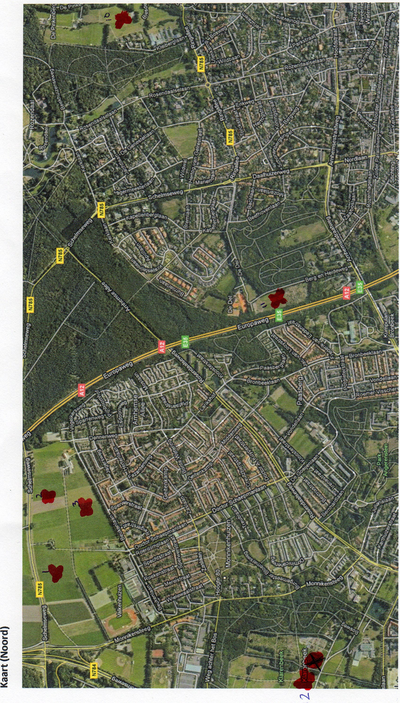
Map North:
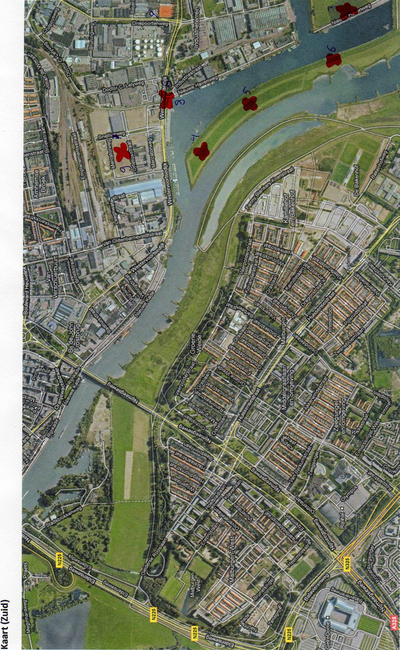
Map South:
Workshop in detail
Before the map is given students are presented with a few photos of the used windturbine type to get an idea of what it looks like.
Students are also given a short list with the main rules including:
- 1 veto right per person (not mandatory to use, but when used must be explained)
- Windturbines may not be placed on the water (only in-land is permitted)
Students need to collaboratively pinpoint a location on the map for the windturbines. Before a location can be marked as definitive, students need to lookup the street on Google Streetview to get an indication of what the area looks like and if it is possible to place a windturbine there. They need to lookup the area by using a computer in the room which is connected to a beamer so everyone can see the area.
Each group member has one veto right. This can be used to vote against a location all of the other group members agree with. This marks the location as unavailable and the windturbine cannot be placed there.
After everyone agrees, the location is written down on a paper.
We need to be aware of the NIMBY-effect (Not In My BackYard)[5]. To overcome this problem we create the map in such a way that someone has no special interest in the various locations. Due to the composition of the group and the maximum of 1 veto per person we can overcome this problem.
Last but not least, windturbines may not be placed in the water. They have to be placed in-land.
The workshop will be videotaped with audio from the moment people enter the room until they leave the room.
Bestand:Workshop Regels.pdf
Planning
The research will take 3 weeks and 4 days.
Workshops will be held in the first week of December.
| Activity | Description | Duration |
|---|---|---|
| Satellite Map | A satellite map of a city in The Netherlands which includes all of the area types | 8 hours |
| Setting up computer | Computer needs to be set up for use with a beamer and Google Maps | 8 hours |
| Selecting research cases | Looking for persons that meet the specifications | 8 hours |
| Conducting workshops | Workshops need to be organised and conducted | 8 hours |
| Data analysis | Analysing the video material | 1 week |
| Researchpaper | Describing the research | 2 weeks |
| Totaal: | 3 weeks, 4 days |
Data analysis
To be able to draw a conclusion from the outcome of the two different workshops we use the following method:
Each group places their windturbines in one of the available areas.
We will count the number of windturbines per area.
In the end we compile a list of areas and their number of windturbines.
The three areas which contain the most windturbines are the result of this research.
A windturbine can best be placed in one of these areas according to students of the RU Nijmegen.
Results
Below are the results of the various workshops.
Workshop 1
Date / Time
16-12-2010 @ 10:30
Location
HG02.053
Recording
Audio + Video (800x600) by Logitech Procam
Group Attendees
Inge, Sanne, Lisa
Roles
Facilitator: Siegert
Workshop Leaders: Kevin & Jeffrey
Minutes: Kevin & Jeffrey
Results
Quantity
Note: numbers depict the order in which windturbines were chosen.
Industry: #7, #8, #9
Harbour/Water: #4, #5, #6
Forrest: -
Pastures: #1, #2, #3
Residential/parks: #10, #11, #12
Map North / South
Pastures
This area was chosen for the first three windmills. There are various pastures on the map, but our test subjects have chosen to place the windturbines
close to each other at the edge of the city and away from the residential area.
Harbour/Water
Because there is a maximum of 3 windturbines per area, our test subjects wanted another area away from the residential area and with enough space to allocate the maximum number of windturbines.
In this area the windturbines are placed on an island in the middle of the water.
Industry
Our test subjects choose this area because it's again away from the residential area and because (in their words) it's ugly anyway.
In the industrial area windturbines are placed at the edge of the area, near the water.
Residential/parks:
For our test subjects it was either this or cutting down the forrest.
In these areas windturbines are placed far away from each other, spread over various places in the city as far away as possible from houses.
Forrest:
Despite the fact that it was allowed to cut trees, our test subjects choose to leave the forrest intact.
The height of a windturbine would have made it possible to place a turbine inside the forrest.
Conclusion
As expected the group started with the most obvious areas. Because of the restrictions of three windturbines per area they had to change to more challenging areas. The group tried to put the windturbines as close together as possible.
The areas most in favor are the most remote areas and the industrial area. It is interesting to note there is a difference in reason why.
The remote area is chosen because there they are visible to as least people as possible. In the industrial area the windturbines are visible, but those areas are 'ugly anyway'. As expected it became progressively harder to find suitable locations.
The group was very cooperative, all locations were considered openly. This meant no member needed to veto a location.
When considering turbines near residential areas more technical aspects were considered, especially the noise production of the windturbines.
After considering the noise production it was decided that residential ares were no good location. Although the remark was made that people should make compromises if they wanted sustainable energy.
In the results you can see that the residential area is chosen but although this area is considered residential, it is not near houses.
Streetview was extensively used, some locations that looked good on the map were discarded after looking around in streetview. There were no locations that looked bad on the map that were chosen because they looked good in streetview.
The goal of this workshop was to find suitable locations for enough large windturbines to provide sustainable energy to a large part of the city. With a few minor surprises the outcome was as expected.
Reflection
During this research we have considered the following alternative for the workshop:
Alternative #1:
- Everyone makes a list, where they want to place the windturbines
- The workshop leader combines all of the lists in one list
- The final list is discussed by the group members
- Each group member gives points to an [x] number of locations
- The locations with the most points are the outcome of the workshop
Further more, during the execution of the workshop we ran into the following:
First, the audio quality of the built-in microphone of the webcam we used to record the workshop was insufficient.
If we need to record a workshop in the future, we will definitely use an external microphone.
Also, during the workshop we gave all of the group members one marker pen. This causes one member to 'dictate' the rest of the group since he or she has the marker.
Another point of criticism is that the groups shouldn't be too large. Originally we planned to have 4-5 members per group.
This is, however, too large for groups that need to determine a location on a map collaboratively. Therefore we decided to shrink the groups to 3-4 persons so everyone can have their say.
We have selected our test subjects randomly from the central hall of the RU, FNWI faculty. Participants followed different studies and had different interests. This is a very good way to gain external validity.
Another interesting point which we found to be very good was the fact that we used a central computer attached to a large screen which participants could use to search a location on Google Maps to gain more insight in an area.
We used a large screen so everyone could participate and not one or two persons would be blocking the screen. This way everyone could participate actively in the location to be chosen.
Last but not least, if you look at the result, it appears that some areas are not completely filled while there is enough space.
This is because of the restriction of three windturbines per region. We've added this restriction to make sure that not all of the windturbines would be placed in just one or two areas.
This could mean that good spots inside an area for windturbines were not chosen and instead a less favorable location in another area was chosen.
Workshop 1 - Minutes
Note: Minutes are in Dutch and only the most important remarks are mentioned here!
Datum: 16-12-2010
Deelnemers: Sanne, Lisa, Inge

Notulist: Kevin, Jeffrey
Fascilitator: Siegert

deelgebieden? Hoe zien we dat?
landelijk gebied, minste last van
bos?
weinig hoogbouw
midden in het weilend, raar?
-> willen rekening houden met bestaande locaties
deelnemers gaan kijken in streetview...
herrie is vervelend voor mensen
3 IN WEILAND: eigenlijk wilen ze er meer plaatsen daar
lawaai naast huis
weiland: weinig mensen last van
langs het water wordt geopperd (de Rijn)
het wordt meerdere keren genoemd dat niemand er last van moet hebben en dat uitzicht belangrijk is
industriegebied en haven worden genoemd
er wordt druk gezocht op de kaart met streetview
het politie hoofdkantoor wordt geopperd, dat is lekker hoog (gelach)
HAVEN/WATER 3
parkeerplaats bij stadion?
willen veel langs water plaatsen
echt collaborative, veto nog niet besproken @ 50%
telling wordt gecontroleerd
er wordt rekening met de kades gehouden
bos ipv. woonwijk voor lawaai, wel zorgen voor wind
allemaal even veel inbreng tot nu toe @ 75%
deelnemers lijken het niet lastig te vinden om er 1 te plaatsen maar de laatste 3 zijn wel lastig te plaatsen
het park is geen optie
de deelnemers vinden windenergie beter dan kernenergie -  men moet er maar iets voor over hebben
overige observatie: in het begin namen Inge en Sanne het voortouw, op ongeveer 30% werkte de hele groep samen
References
- ↑ http://www.scientificamerican.com/article.cfm?id=more-proof-of-global-warm
- ↑ http://windenergie.nl/132/faqs/vragen-beleid/_faq/16#16
- ↑ http://jpl.sagepub.com/content/21/3/255.full.pdf+html
- ↑ http://www.vestas.com/en/wind-power-plants/procurement/turbine-overview/v90-3.0-mw.aspx#/vestas-univers
- ↑ http://en.wikipedia.org/wiki/NIMBY
